
Dearest Readers,
Etta and I have made it to Montana. We're now in the Lewis and Clark Caverns State Park near Whitehall, MT in the south western part of the state.

This is Ian and Bonnie the cheery campground hosts. My tent is in the background under two cottonwood trees. I call this the good and bad campground. It was bad when I first saw the place from the road...pretty flat, congested area with no electricity (of course) and not much shade.

Our tent looks pretty lonely in the hayfield. (cottonwood trees are not visible in pic.) It's a good campsite however, because it has showers...but bad because it costs $2.00 in quarters for 4 minutes of water. (I did it anyway and sped through in 2 minutes out of fear of having a soapy head.) It's a good place at dusk when groups of deer meandered fearlessly across the campground to munch on the meadow. It was bad because at dusk giant mosquitoes attacked both Etta and I. I had to inflate the air mattress fast, toss the sleeping bag and pillow in the tent, and zip it up before the bugs figured out what I was doing. It was good at night to see the dome of infinite stars, but bad because the temperature plummeted to the 40s and I shivered all night. Etta tunneled under a heavy sweater of mine. It was a good place when the wind blew and gently shook the leaves of the cottonwoods trees near the tent. It sounded like a soft rain lulling us to sleep.
Rewinding to the morning, Etta and I drove out of our secluded canyon valley campsite at the previous Dworshak State park, and headed East toward Orofino Idaho, a "gem" of a town. It deserved the gem award given by the state for its cuteness alone. (Orofino also has a big dam and is a logging town).


We traveled on Idaho Scenic Highway 12 that crosses the skinny stovetop of Idaho, hugging the riverbanks of the South and Middle forks of the Clearwater River and the "wild" whitewater Lochsa river.

Route 12 is the historic Lewis and Clark Trail and the Nez Perce trail. Idaho in this area is so beautiful I could cry with joy.


The landscape opened up as Etta and I crossed the border and the continental divide. I left the primeval forests of Idaho for Montana's wider, rockier, and more barren border landscape. I'm on mountain time now, heading for the Rockies visible in the distance near Butte.
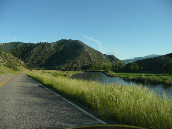
The Jefferson River full to the brim with melting snow flows through the Lewis and Clark State Park area at the end of a long day of driving.


Sounds like you found the Ground Zero campground for Yin/Yang!
ReplyDelete